-
 Michigan Bronco Club
Trails and Parks
Trails contributed by our fellow Bronco owners around the great State of Mchigan. If you have any you'd like to add or any corrections, please shoot us a note.
Gladwin ORV Route
Short ORV route and "gateway" to Northern MI trail system. Lot's of State Forest two tracks surround the ORV Route and ATV trail system. Great place to try out your Bronco without a lot of challenging trail features.
- Duration: 2 Hours
- Moderate
St. Helens Scramble Area
Large, multi use ORV area with areas open to all types of ORVs, including full size (72"+). Lot's of sand, hill climbs, two tracks, you name it. It can get dusty, rutted and filled with washboards, be ready for various and changing conditions.
- Duration: 4 Hours
- Challenging
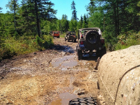
Drummond Island ORV Trails
Michigan's Largest Closed-loop Trail System. Unique ferry access and "rock crawling". What makes Drummond Island the ORV paradise of Michigan? Is it the miles of routes and trails resting beneath the tree canopy? Is it the scenic view of wildlife? The variety of trails and routes suitable for experts and novices alike? The easily accessed food, lodging, entertainment, service, or emergency aid? The clear signage indicating location, destination, and points of interest? Well yes, it is, but all of the items above make it a really good trail system, what makes it great is the ‘secret sauce.’ There you have...
- Duration: N/A (Park)
- Difficult
The Mounds
Have you got what it takes to take on The Mounds? There’s only one way to find out: At Michigan’s premier off-road vehicle facility. At TheMounds.org, they’re your number one source for everything Mounds. So, whether you’ve been ORVing for years or you’re planning your first trip to a place where the road just doesn’t go, whatever it is you need to know, they’ve got it covered. Making grown men cry since 1971. What makes The Mounds the undisputed king of Michigan off-road facilities? Easy: Every day, all week, all year, all kinds...
- Duration: N/A (Park)
- Challenging